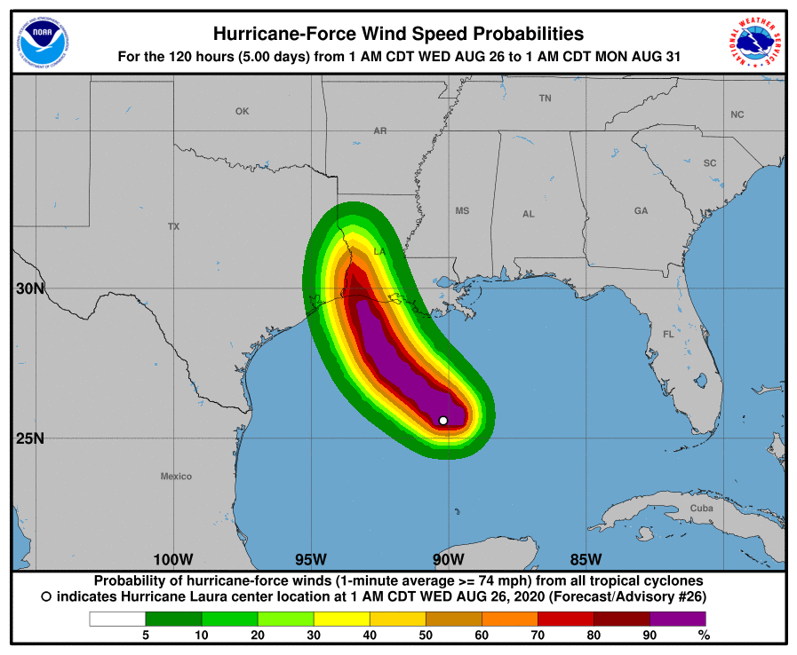
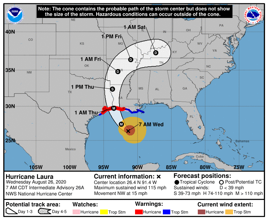
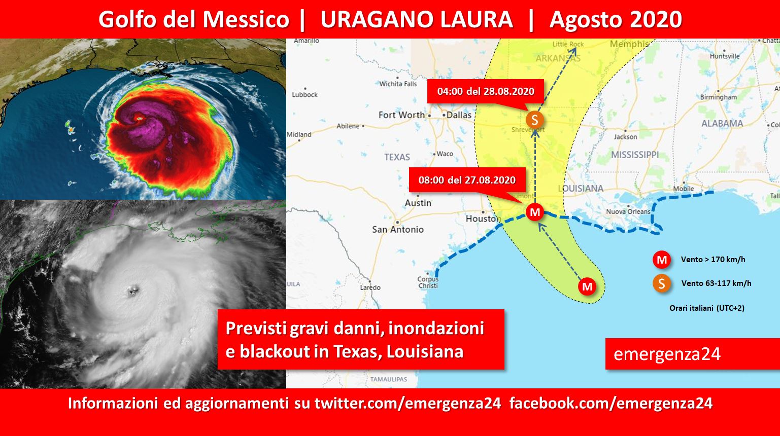
 Preoccupazione per il passaggio di una tempesta tropicale trasformatasi in uragano nel Golfo del Messico a partire dal 20.08.2020. È stato dato il nome di Laura. Previsti allagamenti e danni in Texal e Louisiana.
BILANCIO
Haiti > +21 morti +5 dispersi
Louisiana > 1 morto
CRONOLOGIA INVERSA
27.08.2020 – 20:00 – Declassato uragano Laura a tempesta tropicale.
The NHC has downgraded #Laura to a Tropical Storm with max sustained winds at 70 mph, pressure at 985 mb, & moving N at 15 mph. Full story: https://t.co/8Ytp1u2R77 pic.twitter.com/QsRvE2CW07
— WeatherNation (@WeatherNation) August 27, 2020
27.08.2020 – 14:30 – Informazioni e aggiornamenti
Storm Tracker Von Castor is in Lake Charles, LA tracking Hurricane Laura. He is surveying the damage this morning. pic.twitter.com/NOqPjy6YkU
— Jed Castles News 9 (@JedCastles) August 27, 2020
#Laura is currently a Category 2 and continues to bring damaging winds and flooding inland over Louisiana and life-threatening storm surge to the state’s coastline. Our teams will be LIVE in the field and studio through it all. pic.twitter.com/EzVrelrEC3
— The Weather Channel (@weatherchannel) August 27, 2020
TROPICAL UPDATE: @NOAA‘s #GOES16🛰️ is showing the last 8 hours of #HurricaneLaura‘s path through Louisiana with its infrared band, which provides critical information about hurricanes at nighttime as well as day. Get the latest on #Laura here: https://t.co/VTAp4gGkHs #LAwx https://t.co/pwpsZKE3hY pic.twitter.com/9C7ZRl6wnV
— NOAA Satellites – Public Affairs (@NOAASatellitePA) August 27, 2020
27.08.2020 – 13:00 – Informazioni e aggiornamenti
6am: Latest on Hurricane Laura now down to 105 mph peak winds. Most areas in western Louisiana are still seeing hurricane force wind gusts as it moves north and slowly weakens. pic.twitter.com/9T1U255URg
— Evan Andrews (@EvanAndrewsFox4) August 27, 2020
27.08.2020 – 12:30 – Informazioni e aggiornamenti
#HURRICANELAURA:#Laura is now a Cat. 2 hurricane & continuing to batter Louisiana & move north. It will stay a hurricane through the day before weakening tonight. Massive storm surge, tornadoes, and flash flooding all on the table for Louisiana, Texas, and Arkansas. #27Weather pic.twitter.com/3RiDDBjubP
— Brett Thackara (@BrettThackABC27) August 27, 2020
Hurricane Laura made landfall as a strong category 4 hurricane – the strongest in terms of winds to make landfall in the state since 1856. A 133mph gust was noted just before 3am in Lake Charles. Remains a dangerous storm as it moves NW into NWLA. #WCCB pic.twitter.com/VnBiJ5rF1m
— Nicole Madden (@NicoleMaddenWX) August 27, 2020
#Laura winds are down to 110 making it a category 2 now. pic.twitter.com/9IOdhMSI7k
— Emily Gracey (@GraceyWeather) August 27, 2020
27.08.2020 – 08:30 – Informazioni e aggiornamenti
In it. pic.twitter.com/k8GsOQPRLd
— Josh Morgerman (@iCyclone) August 27, 2020
27.08.2020 – 07:30 – Informazioni e aggiornamenti
Moments away from landfall for #Laura. Winds exponentially increasing. Taking you through the next few hours with @JimCantore and @StephanieAbrams in the field & @weatherdawg1 and @wxbritney in studio with me pic.twitter.com/3pRn7C9JjD
— Mark Elliot (@twcMarkElliot) August 27, 2020
26.08.2020 – 20:00 – Aggiornamenti
#BREAKING: #Laura is now a category 4 hurricane with winds sustained at 140 mph and pressure has dropped to 952 mb. This is an extremely dangerous hurricane with catastrophic and unsurvivable storm surge expected. The latest forecast can be found here:https://t.co/3kEtVud1kI pic.twitter.com/TjgzQ1k9rW
— WeatherNation (@WeatherNation) August 26, 2020
26.08.2020 – 19:30 – FEMA fornisce le informazioni per la protezione personale
Hurricane #Laura will bring catastrophic storm surge that could penetrate up to 30 miles inland from Sea Rim State Park, TX, to Intracoastal City, LA.
If you are told to evacuate, leave immediately. Know where to go for safe shelter, consider staying with family & friends. pic.twitter.com/kBA3m575qk
— FEMA (@fema) August 26, 2020
26.08.2020 – 18:30 – L’uragano è adesso di categoria 4. Ad Haiti ci sono +21 morti +5 dispersi.
26.08.2020 – 18:00 – Thibodaux, Lafourche in Louisiana.
LA 1 remains CLOSED at this time south of the Leon Theriot Lock in Golden Meadow. Here are photos in that area from Golden Meadow and Leeville. #Laura pic.twitter.com/e6JyeJVmpJ
— Lafourche Parish Sheriff’s Office (@LafourcheSO) August 26, 2020
26.08.2020 – 17:30 – Le previsioni prevedono allagamenti con quota dell’acqua a +6 metri.
Unsurvivable storm surge with large, destructive waves will cause catastrophic damage from Sea Rim State Park, TX, to Intracoastal City, LA. Surge could penetrate up to 30 miles inland.
If you need to evacuate, do so NOW. Surge will begin today, well ahead of the strongest winds pic.twitter.com/H6ZgRAiJ14
— National Weather Service (@NWS) August 26, 2020
26.08.2020 – 17:00 – Si prevede che l’impatto possa colpire il Texas e Louisiana. Mappa previsionali e informazioni.
NOAA recon sampling 140 mph winds *at flight level* (~10,000 ft) in the northern eyewall #HurricaneLaura #txwx #lawx pic.twitter.com/SadiovYqO6
— Greg Postel (@GregPostel) August 26, 2020
Infrared imagery from NOAA’s GOES East Satellite shows #Laura continuing its northwestward approach towards the Gulf coast this morning. The system remains on track to make landfall along the TX/LA border late this evening. #txwx #houwx pic.twitter.com/Y89PQ2O33W
— NWS Houston (@NWSHouston) August 26, 2020
xx
“Unsurvivable storm surge with large and destructive waves will cause catastrophic damage from Sea Rim State Park, Texas, to Intracoastal City, Louisiana, including Calcasieu and Sabine Lakes. This surge could penetrate up to 30 miles inland from the immediate coastline.” – NHC pic.twitter.com/4IIqyWxmRZ
— James Spann (@spann) August 26, 2020
#UPDATE Hurricane Laura continues to rapidly strengthen this morning. Winds are now at 125 MPH with a central pressure of 956 mb. This storm is expected to become an extremely dangerous Category 4 Hurricane. More updates on the way on @WeatherNation #Laura #HurricaneLaura pic.twitter.com/2ArKNWrEYq
— WeatherNation (@WeatherNation) August 26, 2020
26.08.2020 – 14:00 – Si prevede che l’impatto possa colpire il Texas e Louisiana. Mappe previsionali e informazioni.


Devastating wind damage will occur near where #Laura makes landfall in the hurricane warning area. Well-built homes may incur major damage, trees will be snapped or uprooted, and electricity and water will be unavailable for several days to weeks. pic.twitter.com/sKWWJt4XDL
— National Hurricane Center (@NHC_Atlantic) August 26, 2020
I should be sleeping but impossible when this is happening with #Laura. Look at the eye starting to get warm and clear out on this satellite loop. Classic signature of a powerful hurricane getting stronger- just horrible to see it so close to the coast. pic.twitter.com/qivuWfgulL
— Eric Blake 🌀 (@EricBlake12) August 26, 2020
25.08.2020 – 13:00 – Ad Haiti ci sono numerose vittime e ingenti danni.
Tropical Storm Laura is lashing #Haiti after knocking out power to homes & businesses. Haitians experienced flash floods in the southeast, wind gusts of 50 miles per hour in the north & severe flooding throughout, including in the capital. 🙏🏽😔 pic.twitter.com/EDJJKMlpmR
— Lunionsuite 🇭🇹 (@LunionSuite) August 24, 2020


 Leggi i