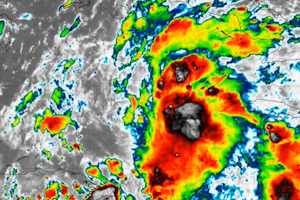
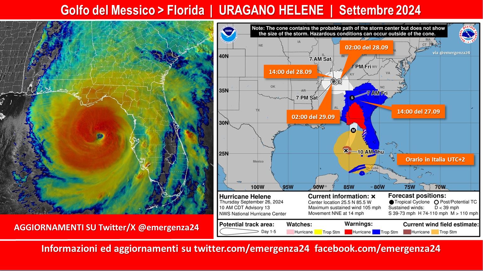
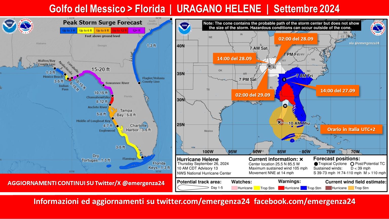
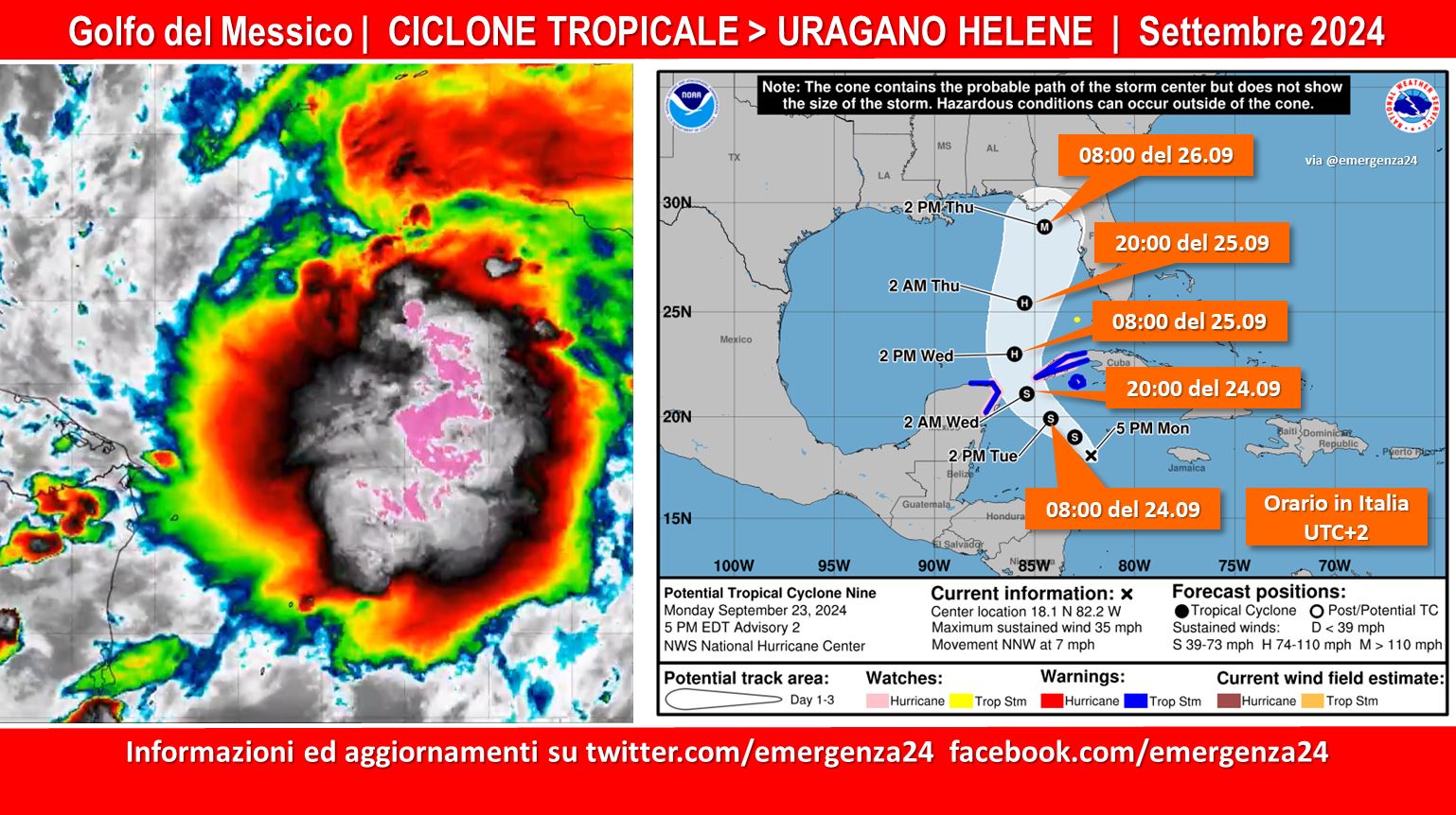
 Preoccupazione per la formazione nel Golfo del Messico del ciclone tropicale Nine (2024) che si è formato a metà del mese di settembre 2024 e potrebbe, passando tra Cuba e il Messico (25.09.2024) toccare le coste della Florida il 26.09.2024 diventando un uragano (hurricane). Questo post verrà aggiornato fino alla fine dell’evento.
CRONOLOGIA BILANCIO VITTIME
02.10.2024 – 22:00 – Il bilancio provvisorio è di +147 morti e centinaia di dispersi
02.10.2024 – 00:00 – Il bilancio provvisorio è di +147 morti e +600 dispersi
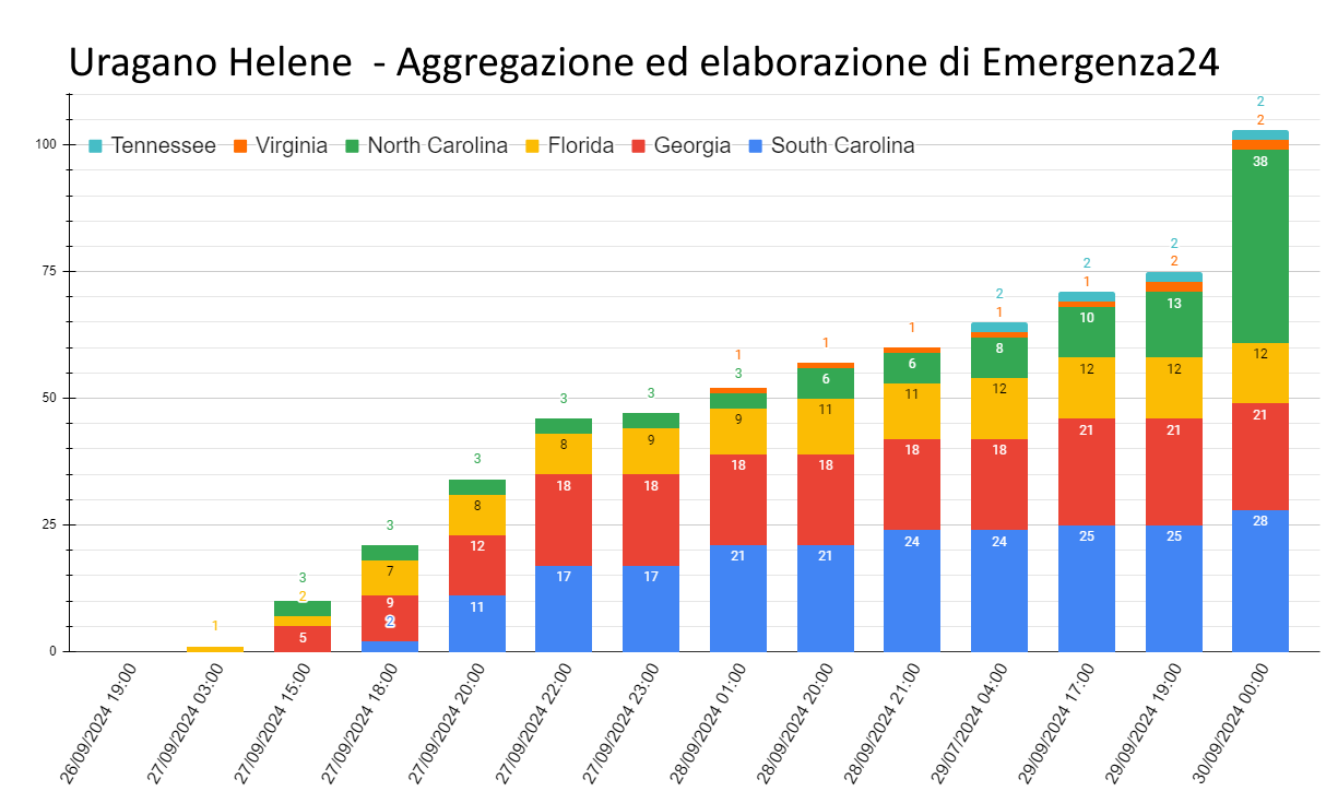
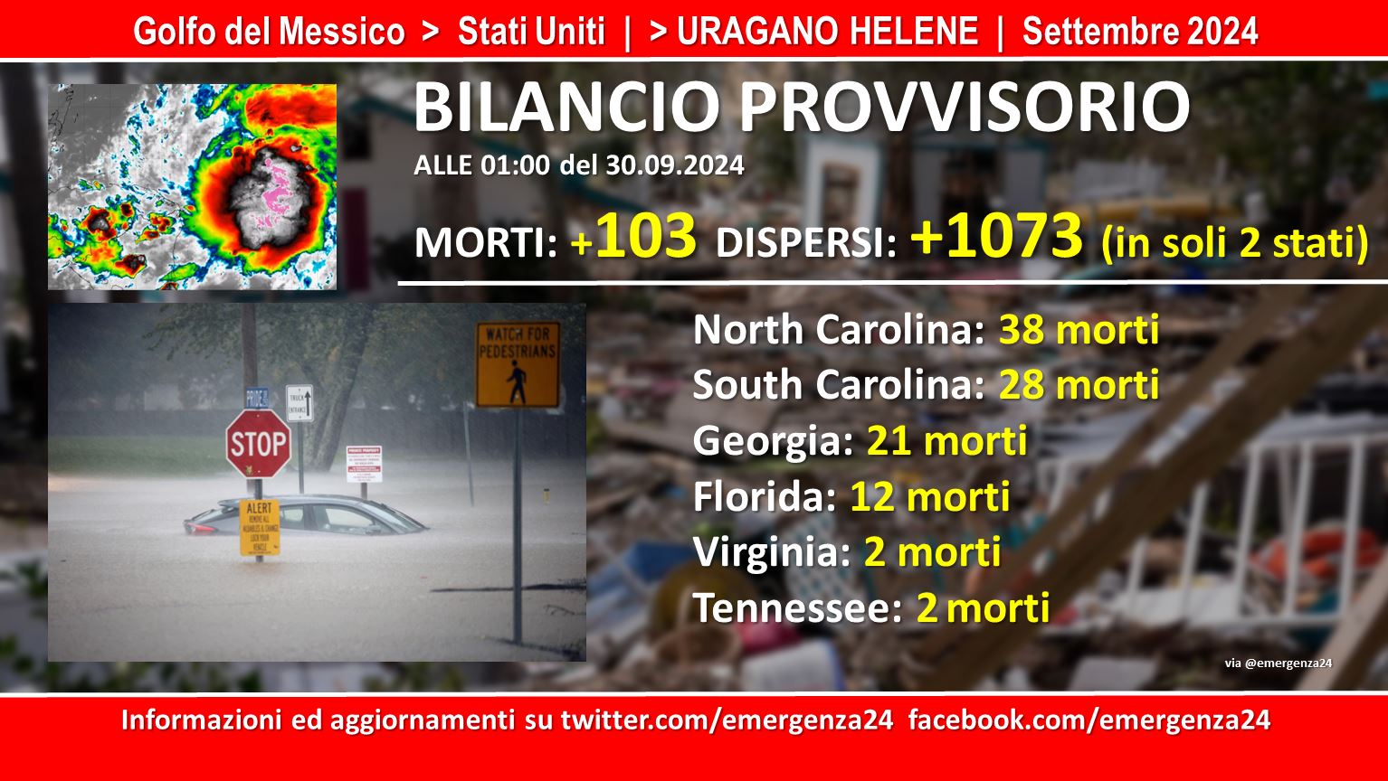
29.09.2024 – 00:00 +103 morti e +1073 dispersi (in soli due stati)
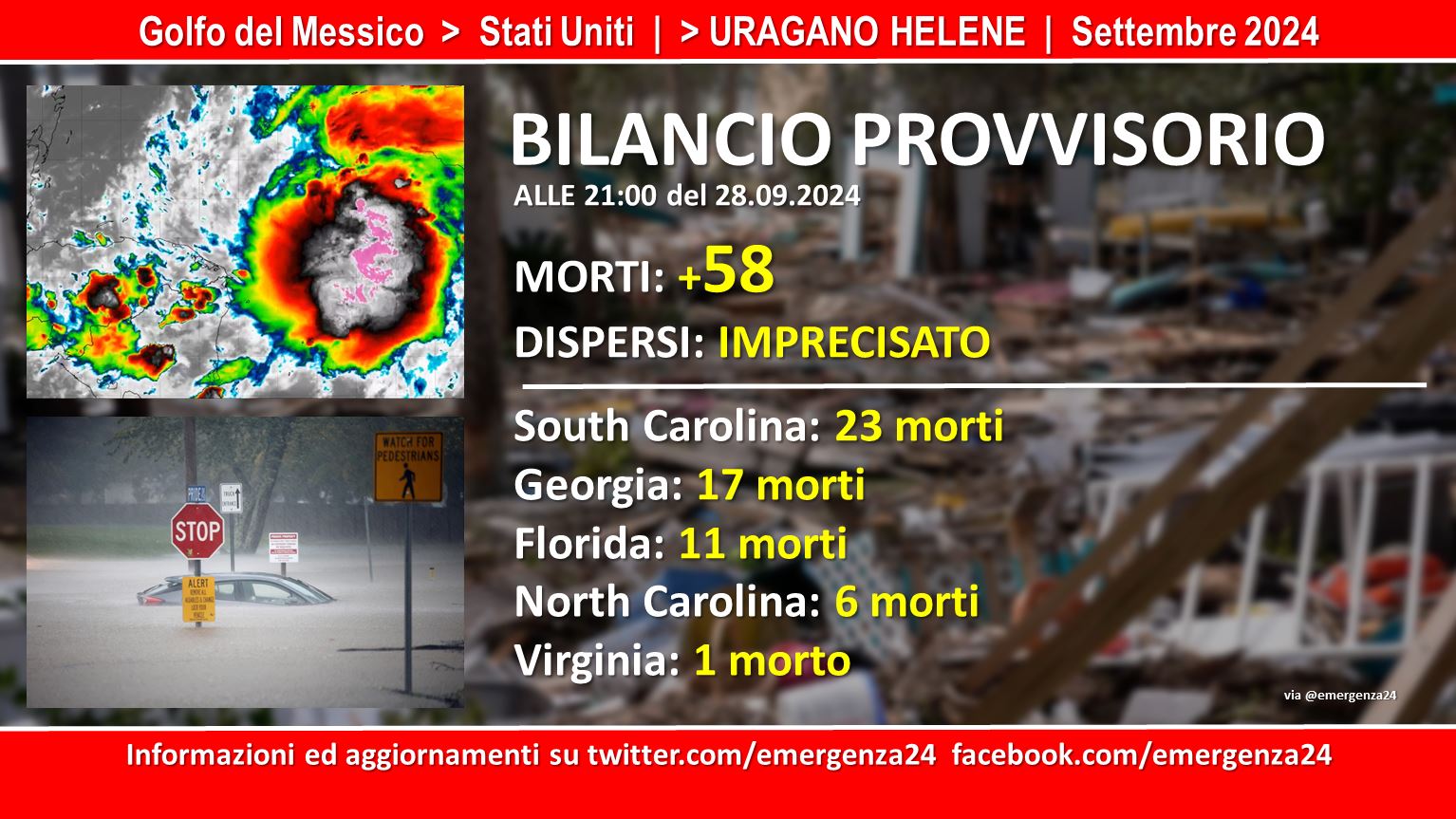
28.09.2024 – 21:00 +58 morti (1 in Virginia, 6 in North Carolina, 11 in Florida, 17 in Georgia, 23 in South Carolina). Imprecisato il numero dei dispersi.
28.09.2024 – 17:00 + 53 morti (1 in Virginia, 6 in North Carolina, 11 in Florida, 15 in Georgia, 20 in South Carolina). Imprecisato il numero dei dispersi.
28.09.2024 – 03:00 +43 morti (17 in South Carolina, 15 in Georgia, 9 in Florida, 2 in North Carolina). Imprecisato il numero dei dispersi.
27.09.2024 – 21:00 – Ci sono +30 morti e un numero imprecisato di dispersi.
CRONOLOGIA INVERSA
30.09.2024 – 00:00 – Bilancio aggiornato delle vittime
28.09.2024 – 21:00 – Informazioni e aggiornamenti
There’s a 50% chance of another Gulf storm developing next week. Most models are on board with development. It is too soon to know where it would track, but we will keep an eye on it and update you. Conditions appear favorable to support development in the Gulf once again.… pic.twitter.com/aIbf8bce4K
— Hurricane Tracker App (@hurrtrackerapp) September 28, 2024
28.09.2024 – 21:00 – Bilancio aggiornato delle vittime
28.09.2024 – 19:00 – Informazioni e aggiornamenti
Our @IndyJenn_ with the latest on #HurricaneHelene‘s catastrophic impact on North Carolina. Our prayers are with our neighbors to the northwest right now… https://t.co/eQeCKzsf4M
— FITSNews (@fitsnews) September 28, 2024
28.09.2024 – 18:00 – Informazioni e aggiornamenti
🚨 OCFA Activated for Hurricane Response 🚨
The Orange County Fire Authority’s California Urban Search and Rescue Task Force 5 (CA-TF5) has been activated and is deploying to North Carolina in response to Hurricane Helene. >>>> pic.twitter.com/4N5JK9AoK6
— OCFA PIO (@OCFireAuthority) September 28, 2024
28.09.2024 – 16:00 – Informazioni e aggiornamenti
3.7 million electric customers remain without power, from #Florida up to #Ohio, due to #HurricaneHelene.
With 1 million still out in #SouthCarolina and 700k out in #Georgia and #NorthCarolina.
[2024-09-28 9:44 AM EDT]https://t.co/kJ0OPcOSrS#PowerOutages pic.twitter.com/5Ps3cFnDFN— PowerOutage.us (@PowerOutage_us) September 28, 2024
28.09.2024 – 02:00 – Informazioni e aggiornamenti
Waterville Dam Is experiencing a failure, Catastrophic impacts are being felt through the area. #Helene #Dam pic.twitter.com/OEetHWcRCx
— Vortex Vision (@_vertexvision) September 27, 2024
Video shows a house in Asheville, North Carolina floating away and collapsing as tropical storm Helene floods the area. 📷: WSOC-TV – Get the latest on #Helene here: https://t.co/W1HlC8OZ2s pic.twitter.com/oHCGuSQ5GZ
— ABC7 Eyewitness News (@ABC7) September 27, 2024
28.09.2024 – 01:00 – Informazioni e aggiornamenti
Oh my god. The live 🚁 footage of Chimney Rock / Lake Lure North Carolina is absolutely devastating 😱🤯#LakeLure #ChimneyRock #NorthCarolina #Helene pic.twitter.com/QV0iZHGDCb
— jessica 🌴 Harris/Walz 2024 (@two_plus_twins) September 27, 2024
Keaton Beach, FL. Families say it’s destruction like they’ve never seen before. Hundreds of people have no homes to go back to. I’m at a loss for words. #Helene @accuweather pic.twitter.com/EX4DijnNzi
— Ali Reid (@alireidtv) September 27, 2024
Chimney Rock in North Carolina got hit pretty hard with #flashflooding, here is a video of the destruction!
Photos of the location before and after #HurricaneHelen!#helene2024 #HELENE #NC #hurricane #evacuation pic.twitter.com/8ysI7yahKJ
— Jakey (@JacobBaker613) September 27, 2024
Scenes from the flooding disaster in western NC south of Asheville near Brevard and Mills River. Locals are shocked, and the entire area is a navigational mess. Barely any service and no power anywhere. More updates to come when service is stable #helene #ncwx #asheville #brevard… pic.twitter.com/UDIKX4iFF3
— Dan Whittaker (@severeforecast) September 27, 2024
At least 54 people were rescued from the rooftop of a Tennessee hospital on Friday after floodwaters due to Hurricane #Helene quickly surrounded the medical center. Video of the rescue operation showed helicopters landing on top of that building and loading people up.… pic.twitter.com/2SMG2Nf0kS
— ABC7 News (@abc7newsbayarea) September 27, 2024
28.09.2024 – 00:00 – Informazioni e aggiornamenti
Heartbreaking scene as catastrophic storm surge leaves Horseshoe Beach, Florida destroyed. Almost every house sustained damage. @MyRadarWX #Hurricane #Helene pic.twitter.com/LcfXADRnEB
— Jordan Hall (@JordanHallWX) September 27, 2024
Heartbroken for my hometown today. #Asheville #Helene pic.twitter.com/421P5UknHF
— Oliver (@Oskar_Zulu) September 27, 2024
27.09.2024 – 23:00 – Informazioni e aggiornamenti
NASA IMERG captured precipitation rates and totals from Hurricane #Helene as it moved across the Gulf of Mexico and made landfall in Florida’s Big Bend. https://t.co/wXvPLmMpEc pic.twitter.com/j66cyN1YXS
— NASA Atmosphere (@NASAAtmosphere) September 27, 2024
27.09.2024 – 22:00 – Informazioni e aggiornamenti
The historic #LakeLure Flowering Bridge appears to be gone. #RutherfordCountyNC #Helene pic.twitter.com/slM2MTAj5W
— Annie M. Dance 🕵️♀️ 📰 (@AnnieMDance) September 27, 2024
This video from the MCSO Aviation Unit shows damage and flooding from #Helene on Anna Maria Island and in Northwest Manatee County. The video is compiled from the initial aerial damage assessments conducted this morning. (Video has no audio.) pic.twitter.com/iBItn604Ou
— Manatee Sheriff (@ManateeSheriff) September 27, 2024
27.09.2024 – 21:00 – Il bilancio provvisorio è di +30 morti e un numero non definito di dispersi
27.09.2024 – 21:00 – Informazioni e aggiornamenti
The full journey of #Helene 🌀
From a Tropical Storm in the Caribbean Sea, to a catastrophic landfall over Florida as a Category 4 Major Hurricane. pic.twitter.com/KolWN4lvt7
— Zoom Earth (@zoom_earth) September 27, 2024
27.09.2024 – 20:00 – Informazioni e aggiornamenti
Over 30,000 cubic feet per second of water flows over Nolichucky Dam near Greeneville, TN. The dam is operating as designed to allow water to flow over the top. Because of heavy rainfall from #Helene, river and lake levels are rising rapidly. pic.twitter.com/coDx6uUUxa
— Tennessee Valley Authority (@TVAnews) September 27, 2024
27.09.2024 – 19:00 – Informazioni e aggiornamenti
Life-Threatening Major flooding and debris flow in Boone.
Video is from my friend Aidan Haas at App State @spann @JimCantore #ncwx #Helene pic.twitter.com/ybWFEmZPYg
— Ethan Clark wx (@EthanClarkWX) September 27, 2024
27.09.2024 – 18:00 – Informazioni e aggiornamenti
🇺🇲🚨FLASH FLOOD EMERGENCY
HENDERSONVILLE, NORTH CAROLINA
Hurricane Helene brings catastrophic #Flooding:
– I-26 closed in both directions
– Multiple cars submerged
– Homes inundatedStay safe, residents!
September 27, 2024 #Helene #Hendersonville #Hurricane #NorthCarolina pic.twitter.com/Qom7xSvJEH
— Weather monitor (@Weathermonitors) September 27, 2024
27.09.2024 – 17:00 – Informazioni e aggiornamenti
#HurricaneHelene aftermath in St. Petersburg, FL
Drone footage of the low lying #ShoreAcres neighborhood. Homes in this neighborhood range from $300k-$5M, & reports from neighbors reveal no houses were spared from flood waters entering
1 home caught fire. Devastating pic.twitter.com/XPmAL1VOlK
— David Salvo (@SalvoMortgage) September 27, 2024
…#HELENE PRODUCING HISTORIC AND CATASTROPHIC FLOODING OVER PORTIONS OF THE SOUTHEAST AND SOUTHERN APPALACHIANS…
…FLASH FLOOD EMERGENCIES IN EFFECT FOR METROPOLITAN ATLANTA, AND MUCH OF UPSTATE SOUTH CAROLINA AND WESTERN NORTH CAROLINA… https://t.co/EItQlVQybI pic.twitter.com/T1Vj5eXjOI
— National Hurricane Center (@NWSNHC) September 27, 2024
Ride through the eyewall of Hurricane #Helene aboard @NOAA WP-3D Orion #NOAA42 “Kermit” during our evening mission on Sept. 26, 2024. This mission gathered crucial data of a large hurricane intensifying before landfall. Find NOAA resources on continuing impacts and post storm… pic.twitter.com/qv0QxLzjp2
— NOAA Aircraft Operations Center (@NOAA_HurrHunter) September 27, 2024
I just ended the long regional radar loop for #Helene after 48 hours: https://t.co/pK3EMVUtlw pic.twitter.com/MrxLBrvHbG
— Brian McNoldy (@BMcNoldy) September 27, 2024
This is the worst flooding I’ve EVER SEEN. Smokey Park Highway in Candler, NC is covered in fast moving water. Do not attempt to cross. #ncwx #helene pic.twitter.com/jgnt9zQ2CZ
— Josh Griffith ⚡ (@JoshGriffithWX) September 27, 2024
27.09.204 – 15:00 – Informazioni e aggiornamenti
🚨 HEROIC RESCUE! The U.S. Coast Guard shared a video of their daring rescue of a man and his dog after their sailboat was disabled during Hurricane #Helene. Both are safe and in good health.
📹: AST2 Hudson, edited by Lt. Cmdr. Kellerman, AirSta Clearwater pic.twitter.com/aD5lpt8cxz
— John-Carlos Estrada 🎙️ (@Mr_JCE) September 27, 2024
27.09.2024 – 09:00
As #Helene approaches, at Tampa General Hospital remains strong, able to withstand 15 ft of storm surge, activated emergency response plans and are ready to care for community 👏💪#HurricaneHelene pic.twitter.com/PcEAaL4OKG
— Bee🐝 (@BeeLady__) September 27, 2024
27.09.2024 – 06:00 – Informazioni e aggiornamenti
11:20pm EDT 26th September — #Hurricane #Helene has made landfall in the Florida Big Bend region at around 11:10pm EDT just E of the mouth of the Aucilla
River.Max sustained winds at landfall were estimated at 140 mph & a min pressure of 938 mb.
Info: https://t.co/1OTHyJkqja pic.twitter.com/WWohcTqpBa
— National Hurricane Center (@NHC_Atlantic) September 27, 2024
27.09.2024 – 04:00 – Informazioni e aggiornamenti
27.09.2024 – 02:00 – Informazioni e aggiornamenti
Category 1 to Category 4 in under 12 hours #Helene pic.twitter.com/G5dWLWqwAh
— Zoom Earth (@zoom_earth) September 26, 2024
#Helene Surge in Madeira Beach due West of Tampa on the gulfpic.twitter.com/cmDOp2sIn0
— Ryan RC Rea (@volvoshine) September 26, 2024
27.09.2024 – 01:00 – Informazioni e aggiornamenti
BREAKING: Helene is now a Category 4 storm with 130mph…This is expected to be an all-time record-breaker since records have been kept (1851) for the most intense storm to ever strike Florida’s Big Bend. #Helene #HurricaneHelene https://t.co/fFTgmQYBp4 pic.twitter.com/5EQ609YB3S
— Rob Perillo (@robperillo) September 26, 2024
Streets are submerged with water here in Fort Myers Beach. High tide isn’t until 1:24am. #Helene #flwx pic.twitter.com/UPBTePTaIF
— Lauren Kreidler (@WeatherWithLaur) September 26, 2024
#Hurricane #Helene is now a Category 4 hurricane with max winds of 130 mph. If it maintains that intensity until landfall, it would be the first Cat. 4+ hurricane on record to make landfall in Florida’s Big Bend on record (since 1851). Prior record – Cedar Key (1896) – 125 mph. pic.twitter.com/DvPNXIMLSB
— Philip Klotzbach (@philklotzbach) September 26, 2024
Nearly 5 feet of storm surge being observed along the western Florida Peninsula this evening due to Hurricane #Helene. Rising tides over the next several hours could exacerbate these levels. Please be safe and aware if you’re in coastal areas. Much worse storm surge is expected… pic.twitter.com/B4XxqhaxFr
— Dr. Levi Cowan (@TropicalTidbits) September 26, 2024
Now officially Cat 4 – max winds of 130 mph. #Helene https://t.co/ypdQJNr7Ty pic.twitter.com/k9djixLO8o
— Dr. Levi Cowan (@TropicalTidbits) September 26, 2024
🚨 #Helene has strengthened to a Category 4 Major Hurricane. Maximum winds 130 mph. Pressure 947 mb. Updated at 22:20 UTC.
See the latest radar map and track here: https://t.co/JnvhmPIFuS pic.twitter.com/mP72omqbhA
— Zoom Earth (@zoom_earth) September 26, 2024
27.09.2024 – 00:00 – Informazioni e aggiornamenti
Generational storm for the Big Bend of Florida. What a catastrophe incoming. #HELENE pic.twitter.com/Dj5hgsGcmC
— Michael Ferragamo (@FerragamoWx) September 26, 2024
Radar data continues to suggest that the eyewall is increasingly dominating the secondary band that had been preventing consolidation of the inner core wind field. Simultaneously, subsidence warming in the eye is strengthening leading to a clearer eye on IR imagery. This probably… pic.twitter.com/ehDZlpWbjJ
— Dr. Levi Cowan (@TropicalTidbits) September 26, 2024
26.09.2024 – 23:00 – Informazioni e aggiornamenti
The Skyway Bridge and the Howard Frankland Bridge are both CLOSED due to high winds and storm surge. Motorists should stay off the highways. #Helene pic.twitter.com/OAM2aMUPEP
— FHP Tampa (@FHPTampa) September 26, 2024
French Broad River in Asheville NC is over its banks and causing flooding to roadways and buildings around Asheville. It is expected to rise through tomorrow and cause potentially historic flooding to the area. Filmed just now. #ncwx #helene pic.twitter.com/EUBIu70tLD
— Dan Whittaker (@severeforecast) September 26, 2024
26.09.204 – 22:00 – Informazioni e aggiornamenti
The latest aircraft data shows a short-term substantial fall in #Helene‘s central pressure to 952mb, coincident with a better-defined eyewall in radar imagery. This indicates a potential pickup in the short-term rate of intensification. We’ll see if it persists as new data comes… pic.twitter.com/qR1JUiS63O
— Dr. Levi Cowan (@TropicalTidbits) September 26, 2024
26.09.2024 – 21:00 – Informazioni e aggiornamenti
Flew with Miss Piggy (#NOAA43) into a strengthening Hurricane #Helene this morning.
Please be prepared if you are in the path.
Follow @NHC_Atlantic and @NOAA_HurrHunter for official updates.
Listen to your local officials. Care for your neighbors. pic.twitter.com/Dfh5lxXUP2
— Tropical Nick Underwood (@TheTropicNick) September 26, 2024
IMPACTANTE | 🇺🇸😨
🔹Imágenes aterradoras del Huracán #HELENE que amenaza con efectos devastadores las próximas horas sobre estados como Florida y Georgia.
🔹La fuerza del mismo se siente en tierra, mar y aire. #ElNacional pic.twitter.com/mTfrzq0ovc
— El Nacional (@elnacionalpy) September 26, 2024
🌀 Thursday video update on Hurricane #Helene as it makes its final approach to #Florida
🌀 Helene is expected to become a Cat 3 or 4 hurricane before landfall
🌀 Extreme impacts are expected along the Big Bend region of Florida, with storm surge flooding possible along much of…
— Dr. Levi Cowan (@TropicalTidbits) September 26, 2024
26.09.2024 – 20:00 – Informazioni e aggiornamenti
As #Helene continues to approach the coast, please do not get overly focused on short-term wobbles in its track, “false” eye locations, or on specific computer model simulations.
EVERYONE along the Florida Big Bend coast is at risk of potentially catastrophic storm surge and… pic.twitter.com/LEFNk9UhXv
— National Hurricane Center (@NHC_Atlantic) September 26, 2024
26.09.2024 -19:00 – Informazioni e aggiornamenti
Hurricane #Helene is now a Category 2 hurricane with max winds of 105 mph. Aircraft data shows a very large wind field, primarily weighted toward the eastern side of the storm. Helene is expected to continue strengthening into a major hurricane (winds >115 mph) later today before… pic.twitter.com/av4iZ9WPnL
— Dr. Levi Cowan (@TropicalTidbits) September 26, 2024
24.09.2024 – 23:00 – Informazioni e aggiornamenti
La tempesta tropicale Helene vista dal satellite GOES. Il sistema evolverà rapidamente a uragano nel golfo del Messico e potrebbe superare la categoria 3 nella giornata di giovedì. Per adesso il percorso lo più probabile è quello che porta alla Florida occidentale. pic.twitter.com/E44TchOOig
— Giulio Betti (@Giulio_Firenze) September 24, 2024
24.09.2024 – 00:00 – Informazioni e aggiornamenti
Latest look at #PTC9 which is looking more & more like TS Helene. It’s definitely getting its act together as convection is starting to wrap cyclonically, hence getting that TC look to it. #tropics pic.twitter.com/uWPXOt5x17
— Ryan Kane (@ryankanerWX) September 23, 2024
The swerve of soon to be #Helene between Mexico and Cuba is unreal. Minimal topography disruptions to its development into a major #hurricane AND follows the juice of the Loop Current… this will be a big one in a short 72 hours. @weathernetwork pic.twitter.com/6lTgMjCPaS
— Rachel Modestino TWN (@ThatMetGirl) September 23, 2024
23.09.09.2024 – 17:00 – Informazioni e aggiornamenti
Potential Tropical Cyclone Nine forms in the northwest Caribbean Sea; expected to make landfall in Florida as a hurricane later this week – NHC pic.twitter.com/xH7wCtQn3J
— BNO News Live (@BNODesk) September 23, 2024

 Leggi i