
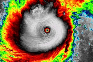
 Segnaliamo Errol il primo ciclone di categoria 5 del 2025 che ha attraversato l’Oceano Indiano posizionandosi a ovest dell’Australia a partire dai primi giorni del mese di aprile 2025 con venti +260 km/h.
CRONOLOGIA INVERSA
16.04.2025 – 18:00 – Informazioni e aggiornamenti
Just 24 hours ago #Errol was still a tropical storm. Since then, it’s explosively intensified to a Category 5 cyclone at 140kt. One of the more impressive rapid intensification events I’ve seen! pic.twitter.com/i3bn6adZQJ
— Alex Boreham (@cyclonicwx) April 16, 2025
16.07.2025 – 17:00 – Informazioni e aggiornamenti
At 919 MBAR, Cyclone #Errol is the most intense storm seen on Earth since Hurricane Milton. pic.twitter.com/Wdi5i9pssj
— Backpirch Weather (@BackpirchCrew) April 16, 2025
16.04.2025 – 16:00 – Informazioni e aggiornamenti
UPDATE: Australian Cyclone #Errol has now achieved sustained winds of 160 MPH (260 KPH) and a cratering, pinhole eye pressure of 919 MBAR, becoming the World’s first CATEGORY 5 Tropical Cyclone of 2025. It took this storm only 18 HOURS to intensify from a Tropical Storm to a Cat… pic.twitter.com/1SCUz0i7Zo
— Backpirch Weather (@BackpirchCrew) April 16, 2025
16.04.2025 – 15:00 – Informazioni e aggiornamenti
Cyclone #Errol has exploded from a Tropical Storm to a 140 MPH (220 KPH) Category 4 whirlpool in just 12 HOURS.
This is extremely rapid intensification occurring in the southern Indian Ocean right now. pic.twitter.com/HFVOf6xCNY
— Backpirch Weather (@BackpirchCrew) April 16, 2025
 Leggi i