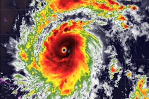
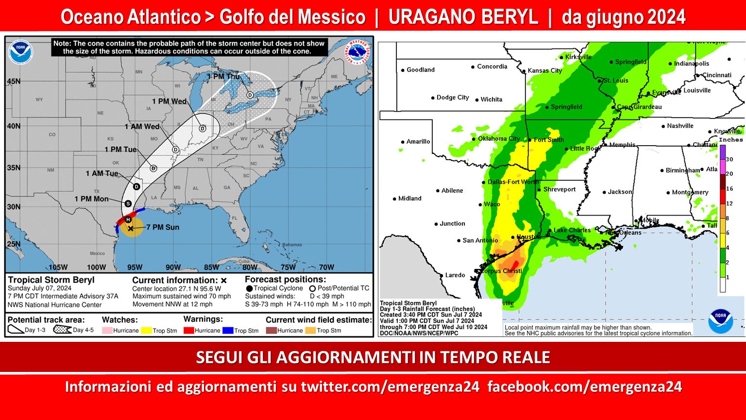
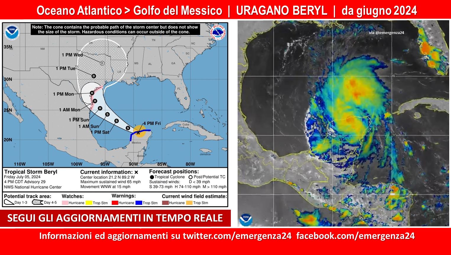
 Preoccupazione per il possibile sviluppo di un uragano che dall’Oceano Atlantico poter passare al Golfo del Messico a partire dalla metà del mese di giugno 2024. Questo post sarà aggiornato fina al termine dell’evento.
CRONOLOGIA INVERSA
08.07.2024 – 02:00 – Informazioni e aggiornamenti
The Hurricane Hunters are flying into Tropical Storm #Beryl and reporting that the storm is intensifying as the sun sets.
Tune in to our LIVE coverage all night for the latest updates or download our TV app to stream: https://t.co/1pcOhXrHyJ pic.twitter.com/sc8hMx3owm
— The Weather Channel (@weatherchannel) July 8, 2024
08.07.2024 – 01:00 – Informazioni e aggiornamenti
18z HMON has #Beryl strengthening to a Cat 2 before making landfall around 4 AM local time in Matagorda Bay. pic.twitter.com/cJRTmRlDyU
— Florida Tropics (@FloridaTropics1) July 7, 2024
07.07.2024 – 23:00 – Informazioni e aggiornamenti
#Beryl is expected to produce flash and urban flooding tonight through Monday night across portions of the middle and upper Texas Gulf Coast and eastern Texas. Minor to isolated major river flooding is also expected. https://t.co/tW4KeGe9uJ pic.twitter.com/acHvoF0qcj
— National Hurricane Center (@NHC_Atlantic) July 7, 2024
07.07.2024 – 21:00 – Informazioni e aggiornamenti
#Beryl getting closer to Houston. NHC says prep for a Cat 2, as rapid intensification is expected as it makes landfall. pic.twitter.com/mhcjWLdAj0
— Brooks Garner (@BrooksWeather) July 7, 2024
07.07.2024 – 20:00 – Informazioni e aggiornamenti
Latest satellite + radar view of Tropical Storm #Beryl as it approaches the Texas coast. NHC still expect it to become a hurricane before landfall. pic.twitter.com/BKdJXJzETu
— Zoom Earth (@zoom_earth) July 7, 2024
07.07.2024 – 19:00 – Informazioni e aggiornamenti
The #TXEMTF currently has 212 personnel and 122 disaster medical assets deployed as part of Texas’ response to Hurricane #Beryl. pic.twitter.com/BjKsUKpcrt
— Texas Emergency Medical Task Force (EMTF) (@TXEMTF) July 7, 2024
07.07.2024 – 18:00 – Informazioni e aggiornamenti
Latest GRAF Model forecast looks pretty dialed in…unfortunately with Beryl moving into a zone with less shear & near 90° sea temperatures “a rapid intensification (RI) is a distinct possibility if the core can become isolated from the dry air that has been inhibiting… pic.twitter.com/m4CHGG5aM5
— Rob Perillo (@robperillo) July 7, 2024
07.07.2024 – 02:00 – Informazioni e aggiornamenti
07.07.2024 – 01:00 – Informazioni e aggiornamenti
#Beryl has now weakened to a tropical storm after crossing the Yucatán Peninsula.
Now Beryl is moving back over the warm waters of the Gulf of Mexico, as is forecast to restrengthen back to a hurricane before striking Texas on Monday. pic.twitter.com/fM8Hn7fdyD
— Zoom Earth (@zoom_earth) July 5, 2024
Besides some dry air, #BERYL will have no problem strengthening over the Gulf, putting the #Texas coast at serious risk.
Rapid intensification is very tricky to forecast, as seen here by the first forecast cone for HARVEY 2017 (right) and BERYL (left). Preparations should be… pic.twitter.com/UV3KtMXCxM
— Michael Ferragamo (@FerragamoWx) July 5, 2024
05.07.2024 – 19:00 – Informazioni e aggiornamenti
Significant damage on the island of #Cozumel.
: Noticias Playa del Carmen#HurricaneBeryl #HuracánBeryl pic.twitter.com/vtHcVCjNZt— . (@RandomHeroWX) July 5, 2024
She devastated Grenada on her way to becoming the earliest Category 5 in recorded history. She outlasted strong wind shear while thrashing #Jamaica and the #Yucatan. Now, Hurricane #Beryl flips the page to the 3rd and final chapter of her sinister saga. She is taking aim at the… pic.twitter.com/6NyU7dDlbV
— Backpirch Weather (@BackpirchCrew) July 5, 2024
05.07.2024 – 18:00 – Informazioni e aggiornamenti
The HWRF model, which has been on the accurate side with #BERYL, forecasts a major hurricane approaching the #Texas coastline early Monday.
Texas needs to begin preparations immediately, as the chance for a hurricane strike (perhaps major) is increasing by the hour. pic.twitter.com/48bLvyLbeF
— Michael Ferragamo (@FerragamoWx) July 5, 2024
05.07.2024 – 17:00 – Informazioni e aggiornamenti
Hurricane #Beryl is now moving away from the Cayman Islands and toward the Yucatán Peninsula of Mexico, where it is expected to make landfall on Friday as a category 1 or 2 hurricane.
Latest NHC forecast and satellite view ️ pic.twitter.com/pTJgq0a81Q
— Zoom Earth (@zoom_earth) July 4, 2024
05.07.2024 – 15:00 – Informazioni e aggiornamenti
TEXANS—the entire TX coast is now in the cone. Models inching northward. You need to have a hurricane plan of action. Hurricane watches for the Texas coast are likely this weekend. While STX has the higher chance from C. Christi south, CTX near Port A can’t be ruled out. #beryl pic.twitter.com/GM0e6a0sBt
— Blake Mathews (@BlakeMathews08) July 5, 2024
05.07.2024 – 14:00 – Informazioni e aggiornamenti
#Beryl makes landfall over the Yucatán Peninsula of Mexico as a Category 2 Hurricane with winds of 110 mph (175 km/h) pic.twitter.com/S0QoRL71Fr
— Zoom Earth (@zoom_earth) July 5, 2024
05.07.2024 – 13:00 – Informazioni e aggiornamenti
Landfall of #Beryl is imminent on the Yucatán Peninsula, intensity is a Cat 2 Hurricane with 90-95knot winds. It will rapidly weaken the next 12 hours due to land interaction. But could quickly restrengthen upon entering Western Gulf where TCHP is moderately high with low VWS. pic.twitter.com/0akvOk22Am
— Riley (@IPTCWCDirector) July 5, 2024
05.07.2024 – 11:00 – Informazioni e aggiornamenti
#BREAKING: a Hurricane Watch has been issued for a portion of the Texas coast from the mouth of the Rio Grande northward to Sargent. #beryl pic.twitter.com/0w7pnOCK9u
— Blake Mathews (@BlakeMathews08) July 5, 2024
05.07.2024 – 10:00 – Informazioni e aggiornamenti
Hurricane #Beryl is jogging north and rapidly closing in on the island of #Cozumel with her glacial, 115 mph eyewall. We are going LIVE soon to cover this very rare, July-time Major Hurricane landfall as Beryl inches closer to the #Yucatan Peninsula. She is much more powerful… pic.twitter.com/vibC1Ljray
— Backpirch Weather (@BackpirchCrew) July 5, 2024
05.07.2024 – 04:00 – Informazioni e aggiornamenti
| URGENTE
El Huracán Beryl se intensifica y vuelve a la Categoría 3 justo antes de su impacto contra la Península de Yucatán en pocas horas. pic.twitter.com/hiy0BMF874
— UHN Plus (@UHN_Plus) July 5, 2024
In complete defiance of the forecasts, Hurricane #Beryl is once again a Category 3 Major Hurricane, attaining very dangerous sustained winds of 115 mph. Most notable with this new update is her core pressure, which has plummeted 12 millibars to 962 mb. Beryl continues to be an… pic.twitter.com/YwwvYq0nPu
— Backpirch Weather (@BackpirchCrew) July 5, 2024
Incredible consistency and accuracy in the track and impacts forecast for #Beryl from the National Hurricane Center
Your efforts certainly do not go unnoticed – thank you for your dedication to the protection of life and property pic.twitter.com/EWcD1Ynjat
— Pat Hyland (@hylandwx) July 4, 2024
04.07.2024 – 17:00 – Informazioni e aggiornamenti
Hurricane #Beryl is now moving away from the Cayman Islands and toward the Yucatán Peninsula of Mexico, where it is expected to make landfall on Friday as a category 1 or 2 hurricane.
Latest NHC forecast and satellite view ️ pic.twitter.com/pTJgq0a81Q
— Zoom Earth (@zoom_earth) July 4, 2024
04.07.2024 – 16:00 – Informazioni e aggiornamenti
Over time, I could see Hurricane #Beryl’s track start to trend more north due to the insane amount of upshear convection being initiated in the northern quadrant today.
In fact, we can see that deviation through EPS plotted over satellite. Notice how #Beryl generally lies north. pic.twitter.com/kGgoGkoNUM
— Michael Igbinoba (@MichaelIgbino10) July 4, 2024
04.07.2024 – 15:00 – Informazioni e aggiornamenti
Latest EURO max wave heights for Beryl. Gulf will depend on final track and intensity. https://t.co/Hk3pbO7x8H pic.twitter.com/3ocgAd2uAO
— Mike’s Weather Page (@tropicalupdate) July 4, 2024
04.07.2024 – 06:00 – Informazioni e aggiornamenti
Drone video shows the devastation of Hurricane Beryl in Jamaica . Beryl the most intense hurricane on record so early. pic.twitter.com/Ad4ZLrp8EK
— April Color (@ColorApril) July 4, 2024
03.07.2024 – 23:00 – Informazioni e aggiornamenti
Devastating likely ongoing on Jamaica’s south coast as Hurricane #BERYL’s center is just south of the island. That puts the most violent part of the hurricane over #Jamaica.
Beryl is moving rather fast, so likely only another couple hours before it passes the island. pic.twitter.com/vFdrz0qtBT
— Michael Ferragamo (@FerragamoWx) July 3, 2024
03.07.2024 – 01:00 – Informazioni e aggiornamenti
Honestly, #Beryl looks more caught up in its own EWRC than it is with shear haha. This is the most resilient storm i’ve ever tracked. #tropics #wx pic.twitter.com/DCslPHeiyW
— Treyce Jones (@TreyceJonesWX) July 2, 2024
01.07.2024 – 21:00 – Informazioni e aggiornamenti
#Beryl =
Historic.
Record-Breaking.
Unprecedented.
All of the above. pic.twitter.com/Ni3fXRBmEV— Heather Zons (@HeatherZWeather) July 1, 2024
#Beryl certainly has the looks of a Cat 5. We’ll see if it can maintain intensity until recon can confirm. Recon departs at 6pm EST. #tropics #wx pic.twitter.com/Xa7gXPaOOM
— Treyce Jones (@TreyceJonesWX) July 1, 2024
30.06.2024 – 19:00 – Informazioni e aggiornamenti
Well this is not what you want to see. Hurricane #Beryl has continued to rapidly intensify and is now a Category 4 hurricane approaching the Windward Islands. Hurricane warnings have been extended to Tobago in addition to Grenada, the Grenadines, St. Vincent, St. Lucia, and… pic.twitter.com/3R3mjq57KP
— Dr. Levi Cowan (@TropicalTidbits) June 30, 2024
30.06.2024 – 18:00 – L’uragano ha raggiunto categoria 4 (indicato come record dagli esperti per il mese di giugno)
BREAKING:
Hurricane #Beryl has become the earliest category 4 hurricane on record, beating out hurricane Dennis, which reached category 4 status late on July 7th, 2005.When ocean heat content is months ahead of the norm, you get tropical cyclones months ahead of the norm. pic.twitter.com/2XDfXq7dzH
— WeatherNation (@WeatherNation) June 30, 2024
BREAKING: Beryl reaches Category 4, the strongest Atlantic hurricane ever recorded in June pic.twitter.com/QGZ7U7e377
— BNO News (@BNONews) June 30, 2024
#Beryl ya es un peligroso huracán categoría 4 con vientos máximos de hasta 215 km/h.
Estén pendientes de las actualizaciones. pic.twitter.com/1makuiJiZ8
— Meteorología Yucatán (@ClimaYucatan) June 30, 2024
BREAKING:
Hurricane #Beryl has become the earliest category 4 hurricane on record, beating out hurricane Dennis, which reached category 4 status late on July 7th, 2005.When ocean heat content is months ahead of the norm, you get tropical cyclones months ahead of the norm. pic.twitter.com/2XDfXq7dzH
— WeatherNation (@WeatherNation) June 30, 2024
30.06.2024 – 17:00 – Informazioni e aggiornamenti
I believe Hurricane #Beryl will surpass 2005’s Hurricane Dennis as the earliest Category 4 Atlantic cyclone by this afternoon. All indications are that explosive intensification is still ongoing within her frigidly violent core, and the eye continues to freeze sharper and denser… pic.twitter.com/53GpqrDv4P
— Backpirch Weather (@BackpirchCrew) June 30, 2024
30.06.2024 – 15:00 – Informazioni e aggiornamenti
BREAKING: Hurricane #Beryl has now been upgraded to a category 3, making it a major hurricane.
The Hurricane Hunters are out now to get some more info on it. Beryl’s expected to continue to strengthen as it heads towards the Lesser Antilles. pic.twitter.com/Y4ZaasyupK
— WeatherNation (@WeatherNation) June 30, 2024
30.06.2024 – 08:00 – Informazioni e aggiornamenti
First signs of an eye beginning to develop at the center of Hurricane #Beryl, a sign of continuing intensification. Deep convection has also become progressively more symmetric about the center over the past several hours, indicating an increasingly well-organized inner core. pic.twitter.com/dFKTLNG7cJ
— Dr. Levi Cowan (@TropicalTidbits) June 30, 2024
30.06.2024 – 05:00 – Informazioni e aggiornamenti
11pm EDT @NHC_Atlantic advisory brings Hurricane #Beryl‘s max winds up to 85 mph currently, forecast to reach 125 mph by Monday morning when Beryl passes through the Windward Islands. Hurricane Warnings have been issued for #Grenada, the #Grenadines, #StVincent, #StLucia, and… pic.twitter.com/leswAVznKW
— Dr. Levi Cowan (@TropicalTidbits) June 30, 2024
30.06.2024 – 00:00 – Informazioni e aggiornamenti
Saturday video update on Hurricane #Beryl which is strengthening quickly on approach to the Caribbean. Residents of the Windward Islands should be making preparations for a potential hurricane strike, with winds potentially over 100 mph, inland flash flooding risks, and coastal… pic.twitter.com/78bHjK1kt3
— Dr. Levi Cowan (@TropicalTidbits) June 29, 2024
29.06.2024 – 22:00 – Informazioni e aggiornamenti
Invest #94L is passing over the Yucatan Peninsula as an area of broad rotation, bringing yet more rain to Central America and southeastern #Mexico. This system could become a tropical depression over the Bay of Campeche before making a second landfall in the Veracruz region of… pic.twitter.com/2p9KawJy12
— Dr. Levi Cowan (@TropicalTidbits) June 29, 2024
29.06.2024 – 21:00 – Informazioni e aggiornamenti
Some confirmation here from AMSR2 showing a developing eyewall, not yet symmetric due to the light easterly shear and vortex tilt, but a sign that #Beryl will likely be a hurricane sooner than later. https://t.co/wXzMQnxTjZ pic.twitter.com/nWLqpfvfqJ
— Dr. Levi Cowan (@TropicalTidbits) June 29, 2024
29.06.2024 – 20:00 – Informazioni e aggiornamenti
Tropical Storm #Beryl (formerly #TD2) has continued to organize and intensify over the last 12 hours, with an inner core now forming in satellite imagery. The vortex appears to be slightly tilted southwestward with height, similar to this morning’s HAFS model depictions, but this… pic.twitter.com/2JWl69usEZ
— Dr. Levi Cowan (@TropicalTidbits) June 29, 2024
28.06.2024 – 19:00 – Informazioni e aggiornamenti
Visible cloud motions show that Invest #95L continues to organize at a gradual pace, incrementally becoming less sloppy. While the surface flow continues to flare northeastward into the monsoon trough boundary on the east side, indicative of the system’s elongated heritage, there… pic.twitter.com/bYtNBGUsIC
— Dr. Levi Cowan (@TropicalTidbits) June 28, 2024
25.06.2024 – 00:00 – Informazioni e aggiornamenti
Looks like @NHC_Atlantic has now added this area to their Tropical Weather Outlook. https://t.co/CCE4zRw0HO pic.twitter.com/GYb9vLflHq
— Dr. Levi Cowan (@TropicalTidbits) June 24, 2024
24.06.2024 – 19:00 – Informazioni e aggiornamenti
Continuing to monitor a tropical wave quickly approaching the Windward Islands, which will track through the Caribbean this week:
A strong ridge to the north could guide the wave into Central America before it has a chance to develop. However, if an upper trough over the SE Gulf… pic.twitter.com/yJxIV4BRUX
— Dr. Levi Cowan (@TropicalTidbits) June 24, 2024
23.06.2024 – 19:00 – Informazioni e aggiornamenti
Invest #93L is weak but teetering on the edge of being a tropical depression just prior to landfall in northern #Mexico. Impacts from this system are limited primarily to heavy rainfall on top of areas already soaked by Alberto just a few days ago. 93L will quickly dissipate… pic.twitter.com/WNhAwYjFOu
— Dr. Levi Cowan (@TropicalTidbits) June 23, 2024


 Leggi i